ভ্রমণ কাহিনী - সান্দাকফু , সিঙ্গালিলা-পাস্ , অমরনাথ
Sandakphu & Singalila Trek. Sandakphu is a wonderland for the trekkers. It's located at an altitude of 11,929ft (i.e. 3,636 meters) in Darjeeling district and north west of Darjeeling hill town. This is the summit or the highest point in Singalila range as well as in the state of West Bengal, India.


এবার চলুন যাই অমরনাথ :-


Sandakphu & Singalila Trek. Sandakphu is a wonderland for the trekkers. It's located at an altitude of 11,929ft (i.e. 3,636 meters) in Darjeeling district and north west of Darjeeling hill town. This is the summit or the highest point in Singalila range as well as in the state of West Bengal, India.
Singalila Pass & Phalut Trek
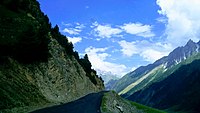
About: This trail starting from Barsey Rhododendron Sanctuary, goes through the last few remaining undisturbed patches of pristine forests in Eastern Himalaya. Due to the proximity of Sikkim and Nepal High Himalayas, the views of High Himalayan ranges are captivating. Crossing the Singalila Pass, the trail joins the famous Singalila Ridge trek at Phalut. Both the places offer majestic views of gigantic massif of Kanchendzongha range in a famous “Sleeping Buddha” formation. On a clear day, these spurs produce magical views of 4 out of the 5 highest peaks in the world, Mt. Everest, Kanchendzongha, Lhotse and Makalu. On later stage the trail gives the opportunity to see interior picturesque villages of Eastern Himalayas. A majority of the trail is full in biodiversity with abundance of Flora & Fauna, specially the Avi-fauna and several species of wildflowers. During spring , the blooming of Rhododendrons and Magnolia brushes the forest with pink, red and white. Both for amateur and experienced photographers the route is bountiful of wild life, flowers, panorama and certainly the Himalayan ranges and peaks. In the later half we enter inside West Bengal while reaching Phalut and the area is inside Singalila National Park. The view from Phalut is equally breath taking. While descending, we stay at Gorkhey, a picturesque village positioned at the confluence of two streams. Samandin
and Rammam are notable villages while reaching our trek end point Srikhola.
Brief Itinerary:
DAY 1: Drive from NJP/Bagdogra to Hilley – 150 Km – 8 hours
DAY 2: Trek from Hilley to Barsey– 4.5 Km – 2/3 hours
DAY 3: Trek to Joributey via Deolinga Dhap – 12 Km – 6/7 hours
DAY 4: Trek to Kharka Dara/Kalijhar via Thulo Dhap – 12 Km – 6/7 hours
DAY 5: Trek to Phoktey Dara and Singalila Pass and descent to Toriphuley – 10 km – 4/5 hours
DAY 6: Trek to Gorkhey via Phalut – 22 Km – 7/8 hours
DAY 7: Trek to Srikhola – 15 Km – 5/6 hours
DAY 8: Drive from Srikhola to NJP – 160 Km – 6/7 hours.
: Being in the Nepal/Sikkim border this area observes longer monsoon. Clouds start to hover from April and prolSeasonong till October beginning. There are two distinct seasons when this year trek is particularly beautiful:
1) Spring/Summer for Rhododendron season: From mid of March to Mid of May. Flowering starts from early March in the lower elevation, and gradually towards end of spring on higher altitude. Rhododendron and Giant Magnolia are two most famous along with several other wild flower species. Cloudy or misty atmosphere is common during Spring. Though clear mountains views are not uncommon, specially during morning.
2) Fall/Winter for clear weather: From October to January. In the beginning of October clouds start moving out from this region and weather becomes clearer. November is particularly known for its crystal clear views of the mountains.
Which season to choose for Goecha La trek?
As like most of the high altitude treks, there are two seasons for Goecha La. The first being the Spring during April and May – the blooming season. The later, Fall, being known for clear weather and spectacular mountain views during Oct and November.
Season: Being in the Eastern Himalayas this area observes longer monsoon. Clouds start to hover from April and prolong till October beginning. There are two distinct seasons when this year trek is particularly beautiful:
1) Spring/Summer trek during Rhododendron bloom: April and May is spring time, blooming time. Flowering starts as early as March in the lower elevation, and gradually towards end of spring on higher altitude. Rhododendron and Giant Magnolia are two most famous along with several other wild flower species. Cloudy or misty atmosphere is common during Spring. Though clear mountain views are not uncommon, specially during morning. For bird watching this is certainly a better season to visit
2) Fall/Post Monsoon for clearer weather: From October to end of November. In the beginning of October clouds start moving out from this region and weather becomes clearer. November is particularly known for its crystal clear views of the mountains. From end of November it becomes very cold at Dzongri and higher. Also being very high altitude the chances of snowfall is high.
Goecha La trek temperatures:
Sikkim Darjeeling and surrounding region is known for its moist weather, almost year around. At higher altitude dampness adds on top of the natural cold conditions.
Usually the minimum temperature of a place is attained early in the morning, 3 to 5 am. During Goecha la trek, there are couple of days (one being the Dzongri top and the other to Goecha La) when you have to leave camp early in the morning. In spring expect the minimum temperature to be around 0°C at Dzongri and Lamuney. In October the temperatures will be similar and temperatures plummet further in late October/November. In November temperature may go down as low as -5°C at Dzongri and -10°C at Lamuney. Do account strong wind at times which in turn can make you feel colder. This is the wind chill factor and feels like temperature can be as lower than the actual. Temperature inside tent will be around 10°C warmer than that of outside. During daytime the temperature will be cooler and can vary from 10°C to 25°C depending upon season and altitude.
Wildlife and bird species during Goecha La trek:
Being inside Himalayan biodiversity hotspot, this trail is teeming with birdlife all the way from Yuksom to Goecha La and back. Spring/summer season needs particular mention. At lower altitude you can spot different species of Bulbul, Woodpecker, Barbet, Sunbird, Thrush, Treecreeper, Tits, at mid altitude Flycatchers, Fulvetta, Magpie, Wren babblers, Laughingthrushes, and at higher altitudes variety of Finches, Accentors, and Grandala.
If you are keen in birds, look carefully around bushes before reaching Dzongri. You may easily spot a Blood pheasant, which is the state bird of Sikkim.
এবার চলুন যাই অমরনাথ :-
94231
The holy cave of Amarnath is a natural cave at about 5800 meters above the sea level in Himalaya range. It is world famous for Shivling ( symbol of Lord Shiva) made of natural ice. One can visit Amarnath from Delhi by Train/ air. From Srinagar one can visit via Gulmarg or Sonemarg. We went via Sonemarg where we had our hotel. From sonemarg the base camp for Amarnath is called ' Beltal'. We took tent there. From Beltal, Helicopter service is available for Amarnath cave. It takes hardly 12 minutes for the helicopter fly. The helipad is just about 500 meters away the holy cave.
The entire journey was fantastic. The scenic beauty of river free flowing from the mountains, the lush green forest, innocent villagers, the atmosphare of pilrimage stands beyond description.
While return we also stayed for 2 days at Srinagar and enjoyed Kashmir.
The entire journey was fantastic. The scenic beauty of river free flowing from the mountains, the lush green forest, innocent villagers, the atmosphare of pilrimage stands beyond description.
While return we also stayed for 2 days at Srinagar and enjoyed Kashmir.
Registration:
For registration, you must know the route you are taking for the Amarnath yatra. Continue reading, it will help you to decide which route to take.
You need to fill the Amarnath Yatra Permit Application Form at any of these registration centres and obtain a Cumpulsory Health Certificate from these authorised health institutes.
Imagine a superhero with infinite powers. The only one who knows the path to immortality. He, however, has to give in to his wife’s wish to know this secret.
To keep the secret safe from any eavesdroppers, the superhero chooses a place safely distant from any life.
En route, he lets go of all his companions. His ride, the bull at Pahalgam. The moon that adorns his hair at Chandanwari. The snakes around his neck at Sheshnag. The five basic elements at Panchatarini. His son Ganesh at Mahagunas Top. To finally reach a hidden cave.
This fascinating story is the legend of Amarnath yatra.
The cave where the superhero (Shiva) supposedly narrated the immortality lessons to his wife (Parvati) – the “holy cave” of Amarnath – has become a revered destination for hundreds of thousands of pilgrims.
Preparation for the Amarnath yatra
We were looking for a trek in Kashmir. The Amarnath yatra was about to start. Everyone suggested we make use of this opportunity.
We are not too religiously inclined. But the prospect of a journey with hundreds of pilgrims and seeing the ice shivling; the world’s most renowned ice stalagmite excited us.
By then, we had spent a few weeks in the Kashmir mountains. We did a few day treks in offbeat places in Kashmir like Chatpal and Yusmarg to prepare ourselves for the Amarnath yatra.
In Pahalgam, we decided to definitely do the Amarnath yatra. Pahalgam is one of the starting points of the Amarnath yatra. However, Pahalgam did not have the Amarnath yatra registration facility.
We got our medical fitness certificates from the government hospital in Anantnag. We then went to the TRC (Tourism Reception Centre) office in Srinagar for the actual registration. Here we were allocated a date for commencing our Amarnath yatra.
Choosing our Amarnath yatra route
We chose the longer route for our Amarnath yatra, from Pahalgam. This is the historic Amarnath yatra route, retracing the steps of Shiva and Parvati. It is a 45 km trek from Pahalgam to the Amarnath cave. We reached the holy cave (this is how the Amarnath cave is commonly referred to) on the third day.
These days, the first 15 km, from Pahalgam to Chandanwari is just a two-hour drive. The actual trek begins only at Chandanwari. (There is another option, which takes one day to reach the holy cave. This shorter Amarnath yatra route starts from Baltal. We will tell you in a while why we believe, the longer Amarnath yatra route is a better option.)
Start of the Amarnath yatra
We had been in Pahalgam for almost a week by then. But the morning we were to start our Amarnath yatra was the first time the clouds cleared. From our hotel room in Pahalgam, we got a clear view of Pissutop. This was the first mountain peak we would climb. It is a fabled “toughest stretch” of the entire Amarnath yatra route. We took this as a good omen and set out.
The water of the Lidder river was bright and clear. The sun was out. The air was crisp. Weather, perfect.
The main road of Pahalgam was choc-a-bloc with people. Excited faces. Some apprehensive. Everyone looking forward to beginning their Amarnath yatra. For many pilgrims, this journey is a dream come true -a once in a lifetime event. Some get so hooked on to it, they keep coming back every year. It was a great chaotic atmosphere.
Dramatic scenes greeted us at Chandanwari. Refreshing welcome drinks were being served to the pilgrims. Fistfuls of dry fruits and chocolates were thrust into our hands. Food-wise, this was going to be a luxury trek!
This route much shorter to the tradition Pahalgam route that pilgrims undertake for Amarnath Yatra. This route is much shorter that the Pahalgam route as it allows pilgrims to take a round trip in 1-2 days. Young and healthy people looking for adventure amidst the religious trip happen to take this route.
Route: Jammu – Srinagar – Baltal – Domali – Barari Marg – Sangam – Holy Cave
Note: The width of this trek is a bit narrow as compared to traditional Chandanwari-Holy Cave route. In addition to that there are some steep rises & falls on the way. It is always recommended to come down from this route as it takes only 1 day to reach Baltal from Amarnath Cave.
Jammu – Baltal: The distance between Jammu to Baltal, which is 400 km, can be covered by taxi or buses. These are available at Tourist Reception Centre J & K Govt, Raghunath Bazaar early in the morning. One can also reach Srinagar by air and then travel to Baltal by road. Passing through beautiful valleys, steeped mountains, one is sure to forget Self as a person and immerse himself in the divinity of Lord Shiva.
Baltal – Holy Cave: The distance between Baltal and Amarnath shrine is mere 14 kms which can be covered by foot or with the help of ponies. There are some steep cliffs and gorges on the way as compared to the Chandanwari route, but pilgrims can return back to Baltal through this route in single day itself.
This is the traditional route of the Amarnath pilgrimage that has been followed by the pilgrims over the years. The distance between Jammu to Pahalgam can be covered by taxi or buses. These are available at Tourist Reception Centre J&K Govt, Raghunath Bazaar early in the morning. One can also reach Srinagar by air and then travel to Pahalgam by road.
Route: Jammu – Anantnag – Pahalgam – Chandanwari – Pissu Top – Sheshnag – Panchtarni – Holy Amarnath Cave
Pahalgam: It is 96 km from Srinagar. This distance can be covered by car, bus or one can hire a taxi. Pahalgam is a small town situated on the banks of Lidder River, known all over the world for its unparallel beauty surrounded by high mountains. All essentials needed for the pilgrimage can be bought here. Good accommodation options are also available at Pahalgam. In addition to that, arrangements for stay and food are also made by the NGOs.
Chandanwari: The distance from Pahalgam to Chandanwari is 16km. The route is relatively good and can be covered by road transport also. Mini buses are also available from Pahalgam to reach Chandanwari with trail running along the Lidder River. Pilgrims camp at Pahalgam or Chandanwari on the first night where food is also available.
Pissu Top: As the Amarnath pilgrimage proceeds further from Chandanwari, one has to climb a height to reach Pissu Top. Legend says that in order to be the first to reach for Lord Shiva, there was a war between Devas and Asuras. With the power of Shiva, Devas decimated the Asuras in such large numbers that the heap of their dead bodies resulted in this high mountain.
Sheshnag: On the second day, one has to partake in 12 km long trek to reach Sheshnag from Chandanwari via Pissu Top. The journey to Sheshnag follows steep inclines on the right bank of a cascading stream and wild scenery untouched by civilization. Pilgrims can take bath and get their fatigue alleviated at this beautiful and scenic place.
Panchtarni: Panchtarni is a very beautiful place in the feet of Mount Bhairav. From Sheshnag one has to climb steep height across Mahagunas Pass at 4,276 m (14,000 ft) for 5 kms and then descend to the meadows of Panchtarni located at a height of 3,657 m. Pilgrims camp at Panchtarni on the third day of their pilgrimage. Due to high altitude, some pilgrims may experience difficulties due to low oxygen.
Amarnath Cave: The Holy shrine of Amarnath is only 6 km from Panchtarni. As there is no place to stay at Amarnath, pilgrims start for the shrine early morning. On the way to holy cave, pilgrims come across the confluence of Amravati and Panchtarni. Some pilgrims take bath at Amravati near holy cave to become pious before going for Darshan. One can return to Panchtarni well in time the same day or continue their journey and reach back Sheshnag by the same evening.